

Could swarms of buzzing drones one day fill the sky, criss-crossing Geelong to deliver food, goods and even people from suburb to suburb?
Luke Voogt speaks to a local pilot who recently helped lay the groundwork for drones to one day take flight in a “seamless sky”.
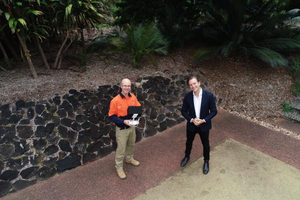
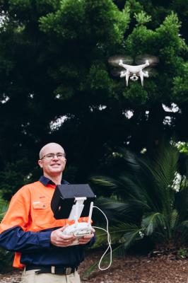
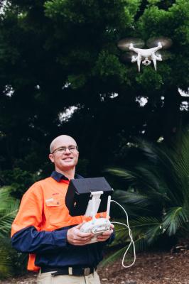
The possibilities of drones are “endless” according Geelong council surveyor Brad Millar.
“It’s limited only by your imagination,” he told the Independent.
“From the perfect cast at your favourite surf fishing spot, to home deliveries of toilet paper in a pandemic, which has been trialled in other areas and proven to reduce traffic congestion.
“Maybe one day we can adapt this technology on a larger scale and use it for personal transport – remember the Jetsons?”
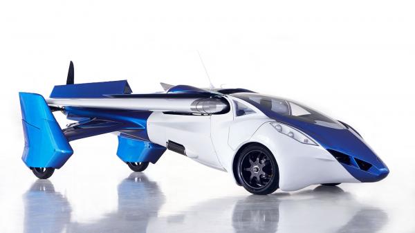
Delivery drones and even flying cars could be closer than we think.
Dozens of start-up companies are competing to develop commercial jetpacks, flying motorbikes and cars, and drones large enough to carry humans.
Slovak company AeroMobil first flew its flying car prototype in 2013 and has begun small-scale manufacture of the vehicle.
Even rideshare company Uber has experimented with flying car prototypes.
COVID-19 has also inspired engineers, entrepreneurs and the average punter alike to explore new uses for drones.
In May 2020 a San Francisco resident made national news by delivering toilet paper to neighbours while the city was in lockdown.
Eighteen countries have deployed drones to deliver medical supplies during the pandemic to prevent the spread of COVID-19, according to UNICEF.
Courier giant Amazon is currently developing Prime Air, a service using autonomous delivery drones to fly packages to customers within 30 minutes of ordering.
But with all these drones buzzing about, the potential for mid-air collisions – not mention invasions of privacy – is ever present.
NASA is currently developing a traffic management program to direct hundreds of thousands of autonomous drones at low altitude.
Back in Geelong, Brad was recently involved in a similar project, if on a smaller scale, mapping the flight paths and systems for drones to operate safely under 120 metres.
Currently the process for approving commercial drone flights is slow and complex.
“There is a lot involved in any safe commercial drone mission,” Brad explained.
“This includes mission planning, checking the airspace regulations, that the weather is OK, the tide is right if you are mapping coastal erosion and making sure the public are well clear.”
Last month aerospace company Thales, Telstra and council joined forces for the Geelong Low Altitude Airspace Management trial.
The trial combined Thales’ traffic management system, currently in use in New York State, and Telstra’s 5G network.
It demonstrated that manned and unmanned drones can operate safely together in a semi-urban environment, according to council.
Council believes the system will eventually speed up the approval process, provide real-time information on current flights and enable authorities to order pilots to change their flight path or land during emergencies or if otherwise necessary.
The system could also prevent privacy violations and improve community safety by requiring pre-approvals for all flights, not just commercial flights.
It would make life easier for Brad, with council already using drones for 20 per cent of its surveying.
“Hopefully this reduces airspace restrictions on drones in the future so we can operate in more locations,” he said.
Brad has been operating drones for three years and, as council’s chief remote pilot, is responsible for ensuring arborists and inspectors conduct safe, properly planned missions.
“I got into drones as they are a great unit for mapping a large area in a short time frame,” he said.
“The most enjoyable part of using drones is we can undertake a volume survey in half a day, which previously would have taken a week.
“Discussions with tree management staff and asset inspectors identified drones as a useful tool to inspect trees for dangerous defects without climbing them.
“As I had the major input in writing the manuals and approval process, I became the chief remote pilot.”
Council uses drones for coastal mapping, aerial tree inspections and taking photos before and after tree plantings.
“The most interesting project to date is monitoring coastal erosion at Portarlington,” Brad said.
Through the project council was able to prove that an artificial reef had resulted in an accumulation of sand, helping to protect the shoreline and properties.
The project won council the 2020 Victorian Marine and Coastal Award for leadership in climate change.
“Hopefully this project is an example to other jurisdictions in the use of drone technology to verify results,” Brad said.
Council also plans to use drones for building and roof inspections and maintenance, to reduce the need for working at heights.
“We can improve safety, as we can survey inaccessible sites from the air, rather than putting our staff at risk, such as working at height,” Brad said.
Recently council used drones for its annual inspection of Geelong Regional Library’s roof.
Drones could also help capture Geelong’s changing landscape and provide 3D data to help planners, surveyors and architects make more informed decisions.
“This is rewarding work, as we are utilising cutting edge technology in our field to improve the way we work,” Brad said.
“The City of Greater Geelong will continue to adapt to the use of new drone technology as it becomes available, particularly if it improves efficiency or safety for our staff and the public.
“We are training some landfill staff to become drone pilots to help manage our landfill operations and are looking at the possibility of traffic assessments and bridge inspections.”
Across Australia last summer, governments and emergency services used drones to achieve previously impossible tasks, like capturing an aerial view of a bushfire within minutes, without putting a pilot in danger.
Organisations like the World Wildlife Foundation have deployed drones to locate injured wildlife and drop tons of carrots for starving animals deprived of food by bushfires.
With pioneers beginning to map the skies and ironing out kinks such as guidance systems, air traffic control and privacy issues, the use of drones is only set to expand.
As Brad says, “Drones are here to stay.”


