By JOHN VAN KLAVEREN
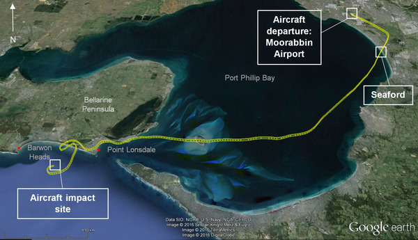
A map released by the Australian Transport Safety Bureau (ATSB) has revealed the twisting flight path of a plane that crashed into the sea off Barwon Heads in January.
The Piper PA-28 Cherokee aircraft was on a flight from Moorabbin airport to King Island when it crashed, killing all four on board.
The four aero club members, Daniel Flinn, Donald Hately, Ian Chamberlain and Dianne Bradley, all from Melbourne’s south-east and aged in their 50s and 60s, died in January 29 crash.
An ATSB report said investigators had still not discovered who was flying the plane before it crashed.
The report said the witnesses including other pilots reported visibility in area where the plane came down was reduced by cloud and rain.
The aircraft left Moorabbin Airport midday and recorded air traffic control (ATC) data showed it climbed to 1000 feet then turned south-west near Seaford.
The aircraft then climbed to 1400 feet tracking over Port Phillip Bay, then west towards the Bellarine Peninsula.
The ATC data also showed that, after passing over Point Lonsdale, the pilot carried out a series of turns, before there was a final steepening and rapidly-descending turn.
A witness fishing about 3 km off the coast near Barwon Heads reported seeing the aircraft descend out of cloud in a steep, nose-down attitude with the right wing lower than the left.
A few seconds later the aircraft hit the water about 200 metres from where the witness was fishing.
Water Police took more than a week to recover the plane wreckage from the sea floor during poor conditions. However the wings were not recovered.
The continuing investigation will exam the pilots’ experience and qualifications, the wreckage recovered, maintenance of the plane, and the weather in the region at the time.
A final report is expected by January 2017.


