Under the Weather, by Lindsay Smail
Geelong recorded almost spot-on average temperatures for June.
The month finished with an average daily low of 6.7 degrees Celsius and a high of 14.3 degrees Celsius, compared to the latest 30-year figure of 6.4 low and 14.5 high – so, despite much public comment, the temperatures were virtually neither warmer nor colder than normal.
Typically for winter, June also recorded many overcast days, a few fogs and a minority of sunshine despite some beautiful sunny weather at times.
The month’s highest maximum was 16.9C on the first day of the month, while the lowest minimum was 0.7C on 14 June.
One frost was recorded, with the lowest maximum temperature of 9.4C on the 24th day of the month – being the coldest June day since 1997.
Most of the region, except for a few small pockets, had average or above-average rain for the month.
Rain was recorded on 21 days, with the maximum fall delivering 8.6mm to Geelong on 18 June. The urban area finished the month with 48mm, compared to the city’s latest June 30-year average rain of 47.3mm.
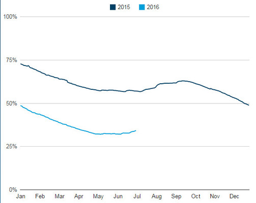
The region’s surface-water catchments grew slightly to finish the month at 34 per cent of capacity.
Among other notable weather events for the month, snow flurries were recorded at Anakie and Warncoort on 24 June. Heavier falls spread right across the Otway ridge the same day with approximately 50mm of snow.
June also had two very windy days on the 22nd and the 23rd, with the highest gust recorded at 70km/h at Breakwater’s official weather station for Geelong.


