Under the Weather by Lindsay Smail
Despite a chilly final week, Geelong’s warmer-than-average May has delivered the city’s warmest autumn on record.
Temperatures for the month were about 1.4C above the latest 30-year average for May, with daily maximums averaging 18.2C compared to 17.1C and minimums 9.9C against 8.3C.
The warmest day recorded a top of 26.4C on 7 May, while the coldest went down to 12.5C on the 26th.
Overnight minimums fell to a low of 1.1C on the last day of the month.
The May results gave Geelong its warmest autumn since records began in 1903. After three months of above-average temperatures, Geelong was 1.6C above the latest 30-year mean of 15.3C.
The previous warmest autumn was in 1988. This follows a recent small increasing temperature trend for autumn since the late 1990s.
Most of the Geelong region received up to double the normal rain for May.
Most of the urban area averaged 80mm to 90mm compared to the 30-year mean of 42mm.
As a result, total autumn rain was around 132mm – much higher than the average 108mm predicted by the Bureau of Meteorology. 
Some of the region’s northwest areas, from Teesdale to Melton, received average rain but less than other areas.
Mt Sabine topped the list with 363.8mm.
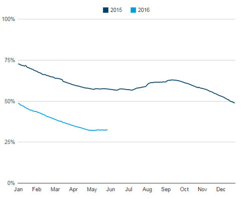
May finished with local water supplies around 33 per cent of capacity and rising slowly.
May also recorded two thunder days but no severe storms. A dust storm engulfed most of Geelong on 3 May when strong winds picked up topsoil from the parched Golden Plains and deposited it over the urban area.
Seven days were windy, with strong north-westerly gusts over 60km/h. The strongest reached 72km/h at Breakwater on the first day of the month and again on 3 May.
- Lindsay Smail operates Geelong Weather Services, phone 5241 5332 or visit geelongweatherservices.com.au.


